Plain-English definitions of property boundary terms you'll encounter when researching property lines, reading surveys, or dealing with boundary issues.
A legal doctrine where someone can claim ownership of land by occupying it openly, continuously, and without permission for a period set by state law (typically 5–21 years). Also known informally as “squatter’s rights.”
A written agreement between neighboring property owners that establishes a shared boundary line, often used to resolve minor disputes without a survey or court action.
The complete history of ownership transfers for a property, from the original grant to the current owner. Gaps in the chain of title can create boundary uncertainty.
A legal document that transfers ownership of real property from one party to another. The deed contains the legal description that defines the property’s boundaries.
A legal right to use someone else’s land for a specific purpose, such as a driveway, utility line, or drainage. The land remains owned by the property owner, but the easement holder has a right to use the specified portion. Common types include utility easements, access easements, and conservation easements.
When a structure, fence, or other improvement extends onto a neighboring property without permission. Common examples include fences built over the property line, overhanging tree branches, or sheds that straddle a boundary.
A fence line is the physical location of a fence, while a property line is the legal boundary defined by the deed and survey. These two lines often do not match — fences are frequently built inside or outside the actual property boundary.
Software that stores, analyzes, and displays geographic data. County GIS systems are the most common way to view property boundaries online, typically through a web-based parcel viewer on the county assessor’s website.
The formal written description of a property’s location and boundaries as recorded in the deed. Legal descriptions use one of several systems: metes and bounds, lot and block, or the rectangular (PLSS) survey system.
A method of describing property boundaries using compass directions and distances measured from a starting point. Common in the eastern United States. Example: “Beginning at the iron pin, thence North 45 degrees East 200 feet...”
A physical marker placed by a surveyor to identify a property corner or boundary point. Monuments can be iron pins, rebar, concrete markers, brass caps, or natural features like trees or stones.
A defined piece of land with recorded boundaries, identified by a unique parcel number (also called APN, PIN, or tax ID) in the county records system. Each parcel has an owner and is subject to property taxes.
A metal rod driven into the ground to mark a property corner. Survey pins are typically iron or steel rebar, 18–36 inches long, and may have a cap stamped with the surveyor’s license number.
A scaled drawing that shows the division of land into lots, including dimensions, boundaries, streets, and easements. Plat maps are filed with the county and are the official record of how a subdivision or development is laid out.
The legal boundary that defines where one property ends and another begins, as established by the deed, survey, and recorded plat. Property lines determine ownership, setback requirements, and building rights.
A lawsuit filed to establish clear ownership of a property and resolve competing claims to the title. Often used in adverse possession cases or when there are gaps in the chain of title.
A type of easement that gives someone the legal right to pass through another person’s property. Common examples include shared driveways, public roads that cross private land, and utility access corridors.
The minimum distance a structure must be built from a property line, road, or other feature, as required by local zoning ordinances. Setback violations can result in fines or orders to remove the structure.
A professional measurement and mapping of property boundaries performed by a licensed land surveyor. A survey establishes the exact legal boundaries of a property and is the only method that produces a legally binding boundary determination.
Insurance that protects property owners and lenders from financial loss due to defects in the title, including boundary disputes, undisclosed easements, or errors in public records.
Entering or using someone else’s property without permission. In the context of property boundaries, trespass can include building on someone’s land, cutting their trees (timber trespass), or using their property as a path.
An exception granted by a local zoning board that allows a property owner to deviate from zoning requirements, such as building closer to a property line than the setback ordinance normally allows.
Local government regulations that control how land can be used (residential, commercial, agricultural, etc.) and what can be built on it, including building height, lot coverage, and setback distances from property lines.
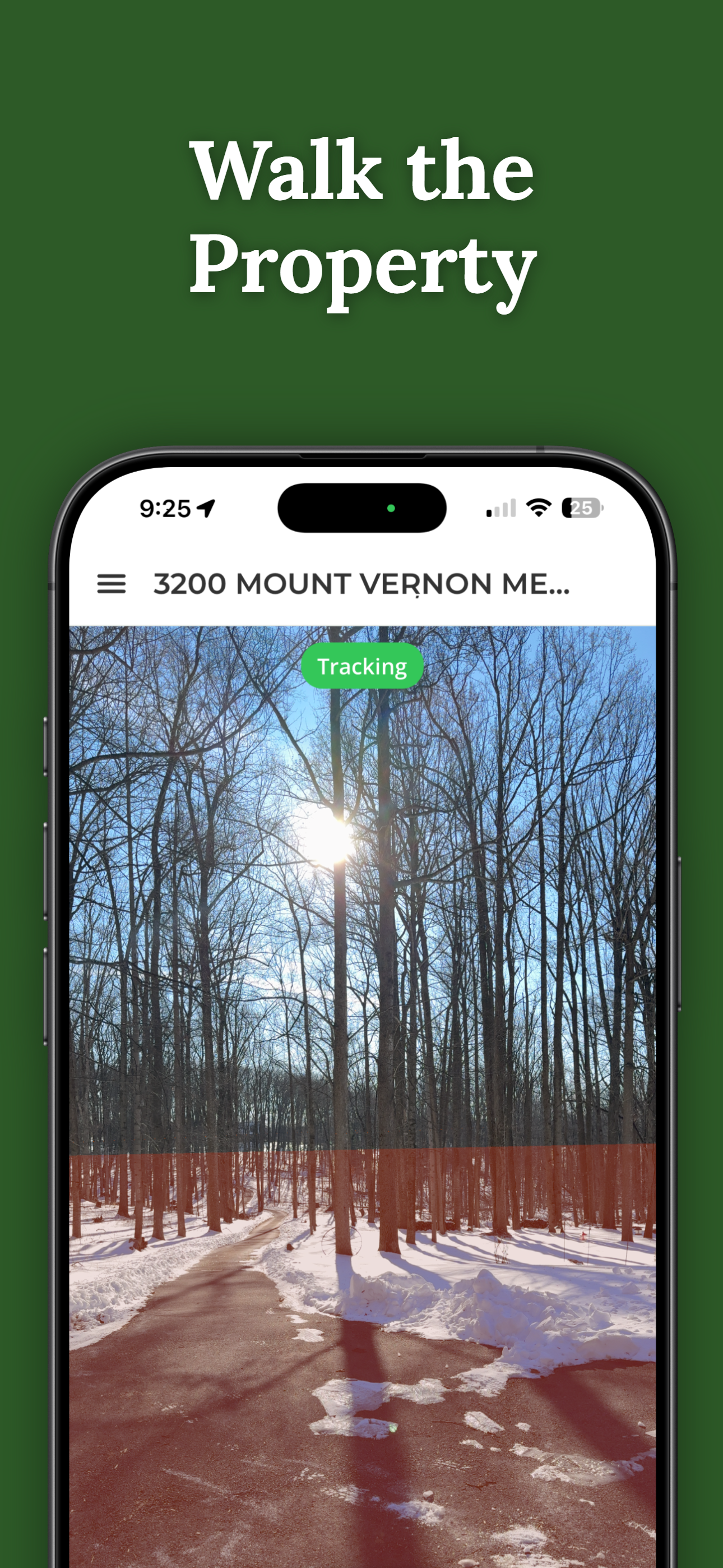
ParcelVision uses augmented reality to project property boundary lines onto the real world through your iPhone camera. Search any address and walk the lines in minutes — no survey appointment needed.
Download on the App Store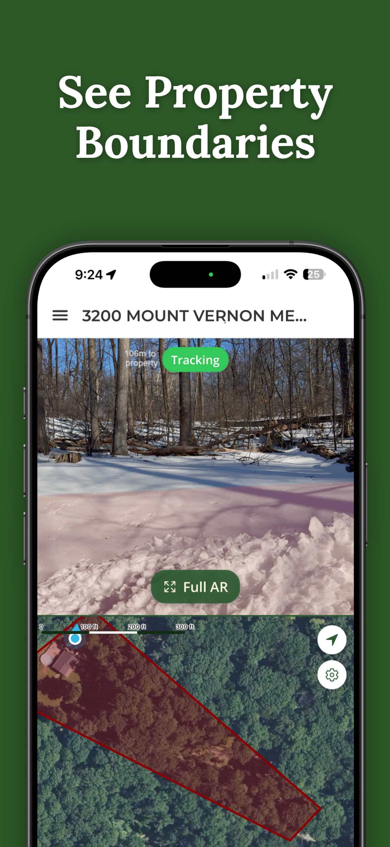
Adverse possession is a legal doctrine where someone can claim ownership of land by occupying it openly, continuously, and without permission for a period set by state law, typically 5 to 21 years. It is sometimes referred to informally as squatter's rights. The requirements vary by state, but generally the possession must be open, notorious, continuous, exclusive, and hostile (without the owner's permission).
An easement is a legal right to use someone else's land for a specific purpose, such as a driveway, utility line, or drainage. The land remains owned by the property owner, but the easement holder has a right to use the specified portion. Common types include utility easements, access easements, and conservation easements.
A plat map is a scaled drawing that shows the division of land into lots, including dimensions, boundaries, streets, and easements. Plat maps are filed with the county and serve as the official record of how a subdivision or development is laid out. They are commonly used by surveyors, title companies, and local government agencies.
Metes and bounds is a method of describing property boundaries using compass directions and distances measured from a starting point. It is common in the eastern United States. A typical metes and bounds description might read something like: "Beginning at the iron pin, thence North 45 degrees East 200 feet." Each segment describes a direction and distance to the next corner of the property.
A quiet title action is a lawsuit filed to establish clear ownership of a property and resolve competing claims to the title. It is often used in adverse possession cases or when there are gaps in the chain of title. The court's ruling removes any clouds on the title and confirms who legally owns the property.
Download ParcelVision and visualize your property boundaries in augmented reality.
Download on the App Store ParcelVision