ParcelVision
Best Property Line Apps in 2026
Yes, there are free ways to view property lines — Google Earth plus your county GIS, or Regrid's free tier — but they're map-only and fiddly. If you want to stand on your land and see the boundary in front of you, ParcelVision is the best choice: search your address free, confirm your parcel's data, then unlock your Virtual Boundary — your property line drawn right on the ground through your iPhone camera — for a one-time $14.99, no subscription. Prefer hunting layers? onX Maps. Quick owner lookups? LandGlide.
Whether you just bought property, need to settle a fence line question, or want to understand your land before hunting season, a property line app can save you significant time and effort. But with several options available, it is not always obvious which one to choose.
We compared five of the most popular property boundary apps across features, pricing, platforms, and use cases. This guide covers what each app does well, where it falls short, and which one makes the most sense for your situation.
Our pick for walking your lines in person: ParcelVision
Search your address free to confirm boundary data is available, then unlock your Virtual Boundary — your property line drawn on the ground through your phone camera — for a one-time $14.99. No subscription.
Search Your Property FreeComparison at a Glance
| Feature | ParcelVision | onX Maps | LandGlide | Regrid | Google Earth |
|---|---|---|---|---|---|
| Best for | Walking your lines in person | Hunting, outdoor recreation | Quick parcel/owner lookups | Professional data research | Free satellite reference |
| How you view it | On the ground + map | 2D map | 2D map | 2D map / data | Satellite |
| Lines drawn on the ground | Yes (Virtual Boundary) | No | No | No | No |
| Pricing | $14.99/property (one-time) | $29.99–$99.99/yr | $9.99/mo or $49.99/yr | Free (basic) / $49/mo (pro) | Free |
| Subscription required? | No | Yes | Yes | Yes (pro) | No |
| Search before paying | Yes — free address search | Trial-based | Trial-based | Free tier | Free (manual setup) |
| Sharing | Unlimited, free | Per-account | Per-account | Limited free | N/A |
| Offline use | Yes | Yes | Yes | No | Limited |
| Platform | iOS | iOS, Android, Web | iOS, Android | Web, iOS, Android | Web, iOS, Android |
1. ParcelVision
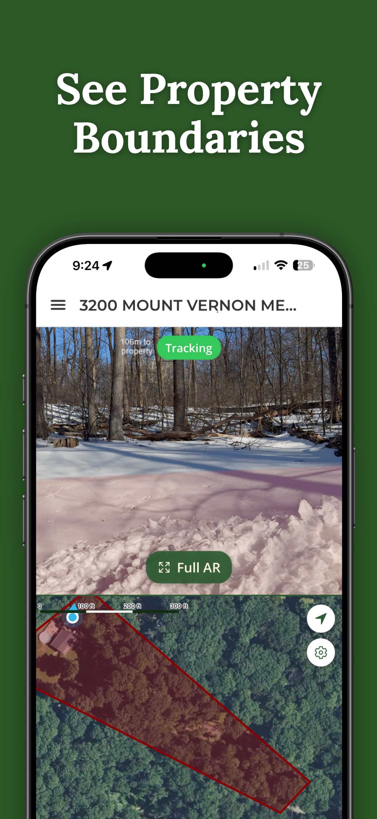
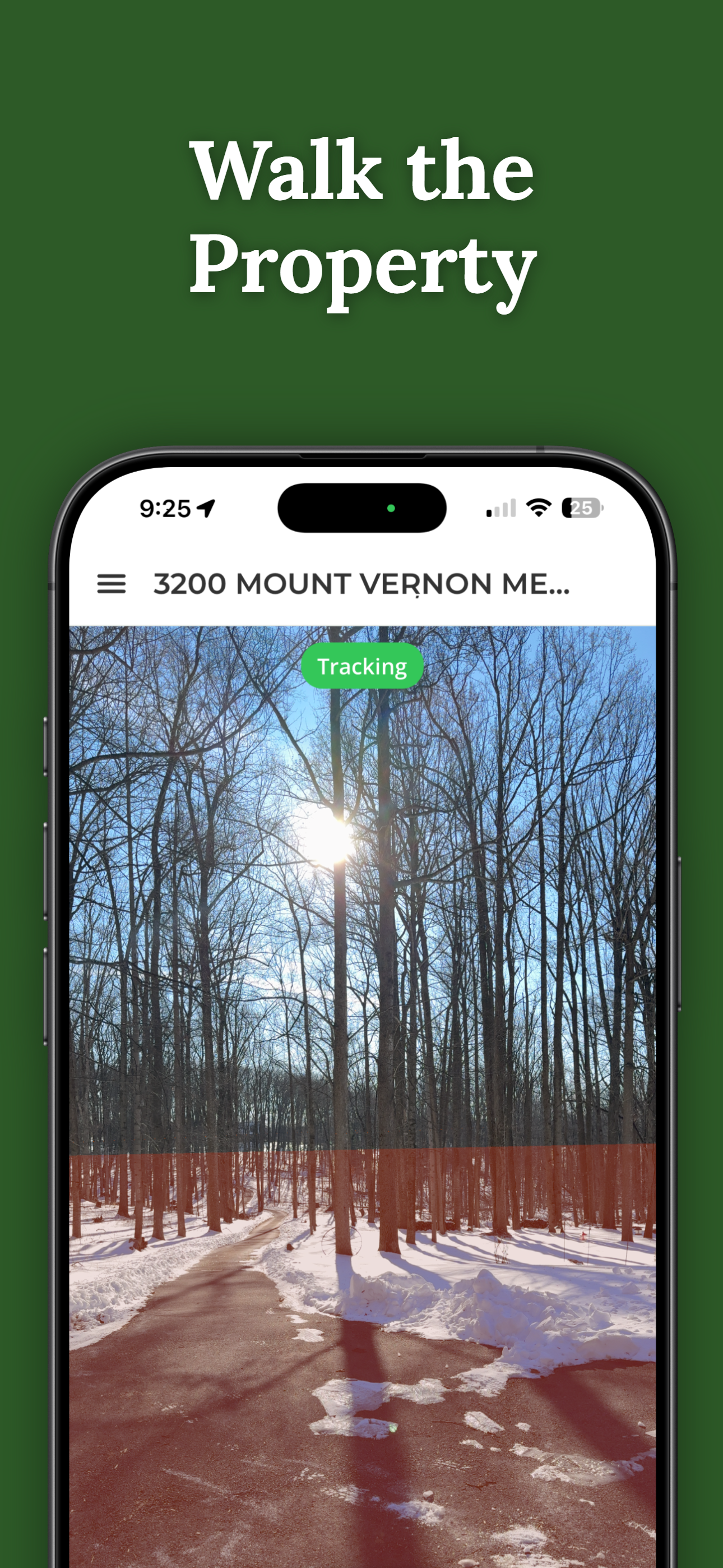
ParcelVision takes a fundamentally different approach from other property line apps. Instead of only drawing boundaries on a flat map, it shows your Virtual Boundary — your property line drawn directly onto the real world through your iPhone camera. You point your phone at the land, and the boundary appears overlaid on what you see, as if it were painted on the ground in front of you.
This on-the-ground approach solves a real problem. With traditional 2D map apps, you are constantly trying to match what is on your screen with what is around you. ParcelVision removes that mental translation step. You can walk along a boundary and see in real time where the line falls relative to trees, fences, and other landmarks. The app also includes a standard map view for orientation.
ParcelVision is also built around a search-first flow. You can search your address and confirm boundary data is available for your parcel before you pay — so you are never charged just to find out whether your data exists. It uses a one-time pricing model at $14.99 per property, which includes unlimited sharing: buy a property card once and share it with family, neighbors, hunting partners, or anyone else for free. There are no subscriptions and no recurring fees.
Pros
- Virtual Boundary draws your line on the ground through your camera
- Search your address free before you pay
- One-time price per property, no subscription
- Share with unlimited people at no extra cost
- Works offline once property data is downloaded
Cons
- iOS only (no Android or web version)
- No trail navigation or route planning
- Reference tool, not survey-grade accuracy
2. onX Maps
onX Maps started as a hunting-focused mapping app and has grown into one of the most popular outdoor mapping platforms available. Its property boundary feature is part of a broader package that includes topographic maps, public and private land layers, GPS tracking, and trail navigation. If you spend a lot of time outdoors and need property boundaries as part of a larger toolkit, onX is hard to beat.
The app's public land layers are especially valuable for hunters. You can quickly see which land is public versus private, identify land management agencies, and plan routes that stay within legal boundaries. Offline maps let you download entire areas for use without cell service, which is essential in remote hunting areas.
onX uses a subscription model with tiers ranging from about $30 to $100 per year depending on the plan and features you need. The higher tiers include additional features like weather overlays and 3D maps. Each subscription is tied to a single account, so sharing means each person needs their own subscription.
Pros
- Public land and land management agency layers
- Trail navigation and GPS route tracking
- Works offline with downloadable map areas
- Available on iOS, Android, and web
Cons
- Annual subscription required ($30 to $100 per year)
- No on-the-ground view; boundaries shown as a 2D map overlay only
- Can be overwhelming if you only need property lines
Choose ParcelVision instead if your goal is to walk one specific boundary in person and see your line on the ground, and you would rather pay once than keep an annual subscription.
3. LandGlide
LandGlide is one of the most widely used property line apps, particularly popular among real estate professionals, homebuyers, and anyone who needs quick access to parcel information. The app overlays property boundaries on a map and lets you tap any parcel to see ownership details, assessed value, and other publicly available data.
The app's strength is speed and simplicity. You open LandGlide, and it immediately shows you property boundaries around your current location or any address you search. It is straightforward and does not require much learning. For real estate agents doing drive-bys or homeowners curious about neighboring parcels, this quick-lookup functionality is the main draw.
LandGlide uses a subscription model at $9.99 per month or $49.99 per year. Property data coverage is extensive across the United States, though the depth of information varies by county. Sharing is tied to individual accounts, so each user needs their own subscription.
Pros
- Property owner data and assessed values included
- Fast, simple lookups by location or address
- Available on both iOS and Android
- Broad nationwide parcel coverage
Cons
- Subscription required ($10/month or $50/year)
- No on-the-ground view; boundaries on a flat map only
- Offline access limited on lower-tier plans
Choose ParcelVision instead if you want to physically walk the boundary and see your line on the ground, and pay once for a property instead of keeping a monthly or annual subscription.
4. Regrid
Regrid (formerly Loveland Technologies) is a parcel data platform that approaches property boundaries from a data-first perspective. It maintains one of the largest parcel datasets in the United States and makes it accessible through both a web interface and mobile apps. The free tier lets you view basic parcel boundaries and limited property details. The professional tier unlocks bulk data exports, API access, and more detailed property attributes.
Regrid is built more for professionals who need property data at scale than for individuals checking a single boundary. Land developers, government agencies, title companies, and researchers are the core audience. If you need to analyze parcels across an entire county or export data for a project, Regrid has capabilities that consumer apps do not offer.
The free tier is genuinely useful for casual boundary checks on the web, but the full power of the platform sits behind the professional subscription at $49 per month. The interface is more complex than consumer-oriented apps, which can be a barrier for people who just want to see where their property line is.
Pros
- Extensive and detailed parcel data nationwide
- Bulk analysis and data export capabilities
- Free basic tier for casual lookups
- Available on web, iOS, and Android
Cons
- Professional tier is expensive at $49 per month
- More complex interface than consumer apps
- No offline mode; data-first, not a field tool
Choose ParcelVision instead if you just want a simple field tool for walking one property's boundary and seeing it on the ground, not a data platform.
5. Google Earth
Google Earth is not a property line app in the traditional sense, but it can be used to view parcel boundaries if you are willing to do some manual setup. Many county assessor and GIS offices publish property boundary data as KML files or through web mapping services. You can download these files and load them into Google Earth to see parcel outlines overlaid on satellite imagery.
The appeal of Google Earth is that it is completely free and most people are already familiar with its interface. The satellite imagery is often higher resolution than what you get in dedicated property apps, which can help with identifying landmarks and features on the ground. For a quick visual reference, it can be a useful starting point.
The significant downside is that Google Earth does not include built-in parcel data. You have to find and import the data yourself, which means locating your county's GIS portal, downloading the right files, and loading them correctly. Not every county publishes data in a format that Google Earth can use. The mobile app also has limited functionality compared to the desktop version, and there is no on-the-ground camera view.
Pros
- Completely free to use
- Familiar, widely-used interface
- High-resolution satellite imagery
Cons
- No built-in parcel data; requires manual KML import
- Setup varies by county and is not always straightforward
- No on-the-ground view; limited mobile functionality
Choose ParcelVision instead if you want built-in parcel search and your boundary drawn on the ground — without hunting down and importing county KML files.
Which App Is Right for You?
Each of these apps serves a different primary use case. Here is a quick guide to help you choose:
Many property owners find that they use more than one app. You might use Google Earth for an initial satellite view, then use ParcelVision to physically walk the boundaries and see your line drawn on the ground. The apps complement each other depending on the situation.
How ParcelVision Is Different
Built for walking, not just looking. Your Virtual Boundary draws the property line on the ground through your iPhone camera, so you see where it falls around you instead of interpreting a flat map.
Search first, pay later. Confirm your parcel's boundary data is available for free before you unlock anything.
One-time unlock, no subscription. $14.99 per property, yours to keep, with unlimited free sharing.
A reference tool, not a survey. Great for walking and planning — not a substitute for a licensed survey.
Search Your Property FreeApp features and pricing are based on publicly available information as of June 2026 and may change. ParcelVision is not affiliated with any of the apps mentioned in this comparison. Property line apps provide boundary visualization for reference purposes and do not replace a professional land survey.